
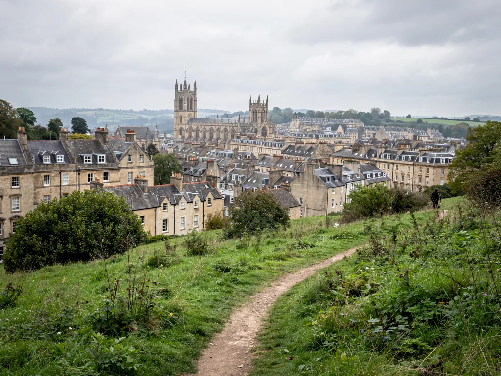
The centre of Bath is compact and mostly level along the river, but the city climbs steeply on every side. Lansdown rises to the north, Combe Down and Claverton Down to the south and east, and Kelston and Weston to the west. That shape gives walkers two kinds of outing: flat routes along the Avon and the canal, and climbs to the green ridges that frame the city. Much of the countryside around Bath falls within the Cotswolds National Landscape. Each section names the source we checked. Paths, access and facilities change, so look at the landowner's current information before you set out, and wear shoes with grip: limestone steps get slippery after rain.
The Bath Skyline
The National Trust looks after a stretch of woodland, meadow and farmland on the south-east edge of the city, which it calls the Bath Skyline. Its best-known route is a circular walk of about six miles (9.6 km) through wildflower meadows, beech woods and fields, with long views over the World Heritage city. For a shorter outing, the Trust also describes a three-mile loop from the city centre out to the ridge, and a family trail of roughly two miles around Claverton Down that suits pushchairs and wheelchairs (source: National Trust, 'Bath Skyline').
The ground holds more history than it first shows. The Trust records Iron Age field systems, stone markers, prehistoric flints and finds of Roman pottery and coins on this land. There is no Trust car park; Bathwick Fields is the nearest start to the Abbey. Some paths have steep, uneven steps, and sheep and cattle graze several fields, so keep dogs on a lead.
Sham Castle and Prior Park
Two eighteenth-century landmarks sit on or near the Skyline, and both go back to one man. Ralph Allen made his money from postal contracts and from the stone quarries at Combe Down, and he did a great deal to promote Bath stone. Sham Castle on Claverton Down is a castle front with nothing behind it. It was built in 1762 by Richard James, Allen's master mason, probably to a design by Sanderson Miller, and its purpose was simply to improve the view from Allen's town house. It is listed at Grade II* (source: Wikipedia, 'Sham Castle').
On the hill to the south, Prior Park is the Palladian mansion John Wood the Elder designed for Allen, and the landscape garden below it was laid out from 1734. The house is now Prior Park College, and the National Trust has cared for the garden from 1993. The poet Alexander Pope advised on the garden, Capability Brown worked on it later, and at the bottom of the valley stands a Palladian bridge, one of only four of its kind left in the world. The bridge is Grade I listed and a scheduled monument (source: Wikipedia, 'Prior Park').
The Kennet and Avon Canal towpath
The flattest long walk from the centre follows the Kennet and Avon Canal. The canal leaves the River Avon at Bath Bottom Lock, south of Pulteney Bridge, and climbs out of the city through a flight of locks. One of them, Bath Deep Lock, was made by joining two older locks during restoration in 1976, and its chamber is 5.92 m deep. The canal opened to through traffic in 1810, fell into decline, and was formally reopened by Queen Elizabeth II on 8 August 1990 (source: Wikipedia, 'Kennet and Avon Canal').
Heading east, the towpath passes through Sydney Gardens, where the canal runs through two short tunnels and under two cast iron footbridges dating from 1800. One tunnel runs beneath Cleveland House, the former headquarters of the canal company. Further out, past Bathampton, the route reaches Claverton Pumping Station, where a waterwheel once lifted river water into the canal, and then the Dundas Aqueduct of 1805, which carries the canal over the Avon and the railway.
Sydney Gardens and the Holburne
Sydney Gardens is a short, level stroll from the centre along Great Pulteney Street. It opened in the 1790s as a commercial pleasure ground called Bath Vauxhall Gardens, after the famous gardens in London. Thomas Baldwin drew the first plans and Charles Harcourt Masters completed them. Jane Austen was among the visitors who came for its promenades and public breakfasts. The Kennet and Avon Canal was later cut through the gardens, and the Great Western Railway followed in 1840, which is why trains and boats both pass through a public park here (source: Wikipedia, 'Sydney Gardens'). The former hotel at the end of the avenue became the Holburne Museum in 1916.
Royal Victoria Park and the botanical gardens
West of the Royal Crescent, Royal Victoria Park covers about 57 acres. Princess Victoria opened it in 1830, aged 11, and it was the first park named after her, seven years before she became queen. The Victoria Column, an obelisk about 10 metres tall, went up in 1837 to mark her coming of age. In the north-west corner, the botanical gardens were laid out in 1887 and hold a large collection of plants grown on limestone. The Great Dell beside Weston Road is an old stone quarry, planted in the 1840s with unusual trees including big North American conifers. Historic England registers the park at Grade I (source: Wikipedia, 'Royal Victoria Park, Bath').
Lansdown, Beckford's Tower and the Cotswold Way
The long climb north up Lansdown Road leads to Beckford's Tower, a 47 m tower designed by the Bath architect Henry Goodridge and completed in 1827 for the writer and collector William Beckford, who used it as a library and retreat. Beckford is buried in the cemetery beside it. The tower is Grade I listed and is owned by the Bath Preservation Trust, which runs it as a museum; it reopened after restoration in June 2024 (source: Wikipedia, 'Beckford's Tower'). The Bath Preservation Trust publishes current visiting details.
Bath is also one end of the Cotswold Way, a National Trail of 102 miles that links the city with Chipping Campden in Gloucestershire. It was inaugurated as a National Trail on 24 May 2007. Heading north from Bath, the path passes the site of the Civil War Battle of Lansdowne (source: Wikipedia, 'Cotswold Way').
Little Solsbury Hill
Above Batheaston, to the north-east of the city, Little Solsbury Hill rises to 191 m. Its flat top is an Iron Age hillfort, occupied from roughly 300 BC to 100 BC. The National Trust acquired it in 1930 and it is a scheduled monument. Peter Gabriel's 1977 single 'Solsbury Hill', his first as a solo artist, was inspired by it (source: Wikipedia, 'Little Solsbury Hill'). The climb is short but steep.
Railway paths: the Two Tunnels and the Bristol and Bath Railway Path
Two old railway lines have become level, surfaced routes for walking and cycling. The Two Tunnels Greenway opened on 6 April 2013 and runs for 3.8 miles from East Twerton to Midford along the former Somerset and Dorset Joint Railway. It passes through the Devonshire Tunnel and the Combe Down Tunnel, and is graded as an easy route, used by cyclists as well as walkers (source: Wikipedia, 'Two Tunnels Greenway').
The Bristol and Bath Railway Path runs for about 15 miles on the trackbed of the Midland Railway's branch from Mangotsfield to Bath, which closed in the 1960s. The charity Sustrans built it between 1979 and 1986, partly with volunteers, and it forms part of National Cycle Route 4. Its Bath end is on the western side of the city, and a riverside path continues into the centre (source: Wikipedia, 'Bristol and Bath Railway Path').
Looking up from the path
Walk any of these routes and you see Bath from above, which is the best way to understand its roofs: grey slate pitches, lead-lined valleys between them, and rows of chimney stacks along every terrace. Empire Roofing Bath repairs and replaces roofs like these on homes and businesses in the city and the towns within 30 road miles. If your own roof needs looking at, start on our roofers in Bath page.