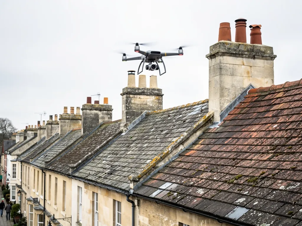
A drone changes one thing about a roof survey: how the surveyor gets a view. Instead of climbing a ladder or standing in the street with binoculars, someone flies a small camera over the roof and records it from a few metres away. For a chimney stack that nobody can safely reach, a steep slate slope above a basement area, or a roof that is too fragile to walk on, that is a real gain. It is quick, it keeps people off dangerous surfaces, and it leaves a set of dated images. What it does not do is look under anything. A drone reads the outer face of a roof, and many of the faults that let water into an older house sit beneath that face, among the nails, battens and underlay, or in lead tucked behind a parapet. A drone survey earns its fee on some roofs and not others, it cannot see everything, and pairing it with hands-on checks at close range gives a result you can actually act on.
What a drone can actually see
A modern survey drone carries a stabilised camera that can record sharp stills and video from close range. Flown carefully, it will show you the following.
- The state of the covering. Slipped, cracked, missing or displaced slates and tiles are usually visible as gaps, uneven lines or differences in colour.
- Ridge and hip lines. Sags, loose ridge pieces and open joints at the top of the roof show clearly from above.
- Chimney stacks. The pointing, the pots, the flaunching (the sloping mortar fillet that beds each pot) and the cap can all be inspected at close range without a ladder.
- Gutters and valleys. Debris, vegetation, standing water and obvious misalignment are visible, as are open sections of valley.
- Flat roof surfaces. Ponding, blistering, splits and ageing of the membrane can be recorded without anyone stepping on the roof.
- Overall form. The whole roof can be shown in one view, which helps when explaining where a fault sits.
This is why drones have become common for first looks. A set of clear, dated images lets an owner see what the roofer sees, and lets a second roofer comment without a second visit. On a tall building it also lets the surveyor decide where scaffold or a tower is worth paying for, instead of putting it up everywhere.
Image quality depends on the day. Strong wind limits where a small aircraft can fly safely, low sun creates harsh shadows that hide detail, and wet slate looks darker and can hide hairline cracks. A competent operator chooses the time and says in the report when conditions were less than ideal.
When a drone survey is the right choice
The best cases are those where reaching the roof is the main difficulty.
Tall or steep roofs are the obvious one. A three-storey Bath terrace with a mansard above a lower-ground floor presents a long ladder, an uneven approach and a steep slope that is hard to walk. A drone gets a close view of the whole front slope in minutes. Chimneys are the second. Many stacks stand on ridges or party walls that cannot be reached without scaffold, and a drone shows cracking, leaning, open joints and missing pots.
Fragile surfaces are the third. Old asbestos cement sheets, cracked fibre-cement, rooflights and weak flat roof decks can fail under a person's weight. Looking from above without stepping on them removes that risk. Large roofs are the fourth, such as a commercial building, a school or a block with a big flat roof, where walking every metre would take hours.
Some situations are about evidence rather than access. If you need a dated record of the roof before a sale, after a storm or ahead of building work next door, images from the air give a clear baseline. Our guide to pre-purchase roof surveys explains where this fits when the roof was flagged in a homebuyer report.
The cost of a drone inspection is typically £200 to £400 according to the roof inspection cost guide published by MyBuilder (2026), against £150 to £250 for a standard inspection. Those are UK averages and do not represent our charges. The drone costs more than a basic look because of the equipment, the flying and the processing of images, so it should be chosen when it solves a real access problem, not as a default.
What a drone cannot see
This is the part that gets left out of a short advert, and it is where owners are most often misled. A drone sees the outer surface of the roof and nothing underneath it. Several of the most common causes of leaks sit out of its view.
Beneath the covering
Everything below the outer course is hidden, including the nails that hold each slate, the timber battens, the membrane beneath them and the rafters. A roof can look tidy from above while its nails have rusted through. That condition, sometimes called nail sickness, is a recognised cause of slates slipping, and only lifting a few slates reveals it. The same applies to the state of the underlay, which may be cracked or torn long before water is visible below.
Hidden lead
Many Bath houses have a parapet gutter, which is a trough lined with lead and set behind a stone parapet, or a valley sunk between two slopes. From above you can see that a gutter has leaves in it or that water is standing. You cannot see the condition of lead that is under water, under moss, or hidden behind the parapet upstand, nor the fine splits at laps and drips that are the usual place for these gutters to fail.
Joints and fine cracks
Hairline cracks in slate, failing mortar in a joint and small gaps behind a flashing may all fall below what a camera sees from a safe flying distance. Lichen, moss and weathering can mask them.
Inside the building
A drone has no view of the loft. Wet timber, condensation, insulation problems, blocked ventilation and the underside of the roof are invisible. A leak inside the house is often the result of a fault that is only found by following the water back from the ceiling.
Why it matters
If a drone survey concludes a roof is in good condition, what it really means is that the surface looks sound. That is useful, but it is not a statement about the fixings, the lead or the timber. We recommend treating it as the first of two steps, with a physical inspection of whatever can be reached to follow.
Combining a drone with hands-on checks
The strongest surveys use each tool where it is best. Images from the air cover the areas nobody can safely reach, and a person on the roof or at the gutter line covers what a camera cannot.
In practice that means starting with a survey of the whole roof from the air, picking out the areas of concern, and then deciding where physical access is justified. A chimney that looks cracked in the images can be examined with a tower. A slope with several slipped slates can be opened in a couple of places to check the nails. A parapet gutter is walked and the lead is pressed and photographed, because there is no substitute for that. Inside, a look from inside the loft at the roof structure can show daylight, damp staining and rotten timbers.
A written report then ties it all together. Each image has a location, each defect has a note of its cause, and the report makes clear which findings came from the drone and which from a person with a hand on the roof. Our guide to the roof condition report explains how that document should be laid out so the sources are plain.
This approach also keeps cost in proportion. If the images show a simple, sound roof, a modest hands-on check may be enough. If they show signs of trouble, you know where to spend. In both cases, you avoid paying for scaffold on every elevation merely to learn what the roof looks like.
Treat any drone result as a description of the surface. The fixings, the lead and the timber need a closer look before anyone can call the roof sound.
Drone survey or building survey: choosing between them
People often confuse a drone roof survey with a building survey, and they answer different questions. A building survey looks at the whole property, including structure, damp, drainage and services, and the roof is one part of it. A drone roof survey looks only at the roof. If your question is whether the house is sound, you need the first. If your question is what is wrong with a particular roof that nobody can reach, the drone may be the better tool. Our page on roof survey versus building survey goes through how to choose.
Consent is a separate matter. A drone survey alters nothing on the building, so it needs no permission from the planning authority, though work that follows might. Listed building consent, issued by B&NES Council, is required before repairs that change the roof's character on a listed house. Where an unlisted house stands in a conservation area, raise any change of material with planning first. The Bath designation is worth knowing: UNESCO status applies to the entire city, but conservation area rules reach roughly one half of it.
There are also rules about where and how a drone may fly, and about privacy when the camera points at neighbouring windows and gardens. We have a separate page on the rules for drone roof surveys, and you should read it before booking anyone. Whoever flies for you should be able to explain how they handle those points, and what they do with the images afterwards.
When we price work, we normally go onto the roof ourselves and photograph the actual slopes during the free survey. Where height or fragility makes that unsafe, we tell you and agree the safest way to get the view we need, which can include aerial images. If you have older photographs of the roof, from a sale listing or a past repair, send them over, as comparing them with new ones shows what has changed. The roof inspections hub describes what each visit involves, and any aerial images are kept with the report so you can compare them later.